4.3.1.2. Route (FV)
Note
Route is identified as Fully Validated.
4.3.1.2.1. Example Route
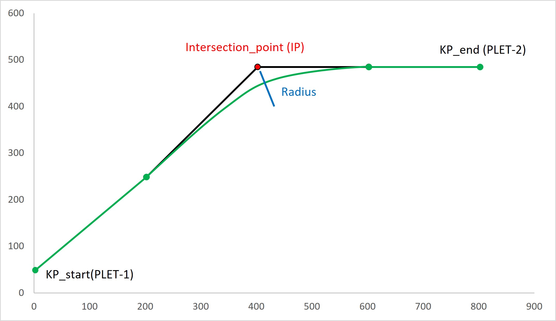
{
  "pdef_id": "ae0df9c9-cf1a-4c51-99ae-ce8640fa4161",
  "pdef_type": "route",
  "meta_data": {},
  "additional_data": {},
  "life_phase": "design",
  "descr": "From PLET-1 to PLET-2",
  "kp_start_descr": "PLET-1",
  "kp_start_point": {
    "type": "Point",
    "coordinates": [
      2.35,
      48.85
    ],
    "crs": "EPSG:4326"
  },
  "kp_end_descr": "PLET-2",
  "kp_end_point": {
    "type": "Point",
    "coordinates": [
      802.35,
      448.85
    ],
    "crs": "EPSG:4326"
  },
  "easting_northing_linestring": {
    "type": "LineString",
    "coordinates": [
      [
        2.35,
        48.85
      ],
      [
        202.35,
        248.85
      ],
      [
        602.35,
        484.85
      ],
      [
        802.35,
        484.85
      ]
    ],
    "crs": "EPSG:4326"
  },
  "bathymetry_multipoint": {
    "type": "MultiPoint",
    "coordinates": [
      [
        2.35,
        48.85,
        -1750.0
      ],
      [
        202.35,
        248.85,
        -1720.0
      ],
      [
        602.35,
        484.85,
        -1700.0
      ],
      [
        802.35,
        484.85,
        -1700.0
      ]
    ],
    "crs": "EPSG:4326"
  },
  "intersection_point_radius": [
    [
      {
        "type": "Point",
        "coordinates": [
          402.35,
          484.85
        ],
        "crs": "EPSG:4326"
      },
      {
        "val": 800.0,
        "unit": "m"
      }
    ]
  ],
  "flow_direction": true,
  "length": {
    "val": 895.0,
    "unit": "m"
  }
}
The figure shows the route defined in this example
4.3.1.2.2. Schema Route
-
pdef.model.route.Route Parameters defining the Pipeline (FV) route, including location of start and end points, length, Kilometer Post (KP) 0 conventions and the like.
Show JSON schema
{ "title": "Route", "description": "Parameters defining the :ref:`Pipeline` route, including location of start and end points, length, Kilometer Post (KP) 0 conventions and the like.", "type": "object", "properties": { "pdef_id": { "title": "PDEF id", "description": ":ref:`pdef_id` is the unique identifier for the object.", "example": "14474720-db23-453a-b9c0-6a9fc9b03ef3", "type": "string" }, "pdef_type": { "title": "Pdef Type", "const": "route", "type": "string" }, "meta_data": { "title": "Metadata", "description": "Optional user free structured :ref:`Metadata` object.", "example": "{'created':'2021-09-03'}", "allOf": [ { "$ref": "#/definitions/MetaData" } ] }, "additional_data": { "title": "Additional Data", "description": "Optional user free structured :ref:`Additional Data` object.", "example": "{'color':'grey'}", "allOf": [ { "$ref": "#/definitions/AdditionalData" } ] }, "life_phase": { "title": "Name", "description": "The pipeline life phase to which this route is related.", "enum": [ "design", "installation", "as-built", "inspection" ], "type": "string" }, "descr": { "title": "Description", "description": "Descriptive text for the route.", "maxLength": 1000, "type": "string" }, "kp_start_descr": { "title": "KP Start Description", "description": "Short description of location selected as pipeline starting point and KP 0.", "maxLength": 256, "example": [ "spool/pipeline tie-in point on as-built drawing XXX rev. 1" ], "type": "string" }, "kp_start_point": { "title": "Location of Starting Point (KP 0)", "description": "GeoJSON :ref:`Point` for localizing kp_start.", "allOf": [ { "$ref": "#/definitions/Point" } ] }, "kp_end_descr": { "title": "KP End Description", "description": "Short description of location selected as pipeline endpoint.", "maxLength": 1000, "example": [ "spool/pipeline tie-in point on as-built drawing XXX rev. 1" ], "type": "string" }, "kp_end_point": { "title": "Location of End Point (KP end)", "description": "GeoJSON Point for localizing kp_end.", "allOf": [ { "$ref": "#/definitions/Point" } ] }, "easting_northing_linestring": { "title": "Easting, Northing coordinates", "description": "GeoJSON :ref:`LineString` of easting and northing coordinates.", "allOf": [ { "$ref": "#/definitions/LineString" } ] }, "bathymetry_multipoint": { "title": "Bathymetry profile ", "description": "GeoJSON :ref:`MultiPoint` of bathymetry - water depth -.", "allOf": [ { "$ref": "#/definitions/MultiPoint" } ] }, "intersection_point_radius": { "title": "Intersection point with curve radius", "description": "Array of GeoJSON :ref:`Point` of intersection points and associated curve radius.", "type": "array", "items": { "type": "array", "items": [ { "$ref": "#/definitions/Point" }, { "$ref": "#/definitions/Length" } ] } }, "flow_direction": { "title": "Direction convention for the conveyed fluid flow versus the KP.", "description": "`True` if the direction of the flow follows the KP, `False` otherwise.", "default": true, "type": "boolean" }, "length": { "title": "Route Length", "description": "The projected route length.", "example": { "val": 12.568, "unit": "km" }, "allOf": [ { "$ref": "#/definitions/Length" } ] } }, "additionalProperties": false, "definitions": { "MetaData": { "title": "MetaData", "description": "Optional base JSON-fragment used to report meta data. User free structure.", "type": "object", "properties": {} }, "AdditionalData": { "title": "AdditionalData", "description": "Optional base JSON-fragment used to report additional user specific data. User free structure.", "type": "object", "properties": {} }, "Point": { "title": "Point", "description": "Base model for all geo-referenced objects.", "type": "object", "properties": { "type": { "title": "Type", "const": "Point", "enum": [ "Point", "LineString", "Polygon", "MultiPoint", "MultiLineString", "MultiPolygon" ], "type": "string" }, "coordinates": { "title": "Coordinates", "description": "Single position. A position is an array of 2 or 3 floats (long, lat, el), see GeoJSON documentation.", "examples": [ 2.3393476009368896, 48.857771121284145 ], "anyOf": [ { "type": "array", "items": [ { "type": "number" }, { "type": "number" } ] }, { "type": "array", "items": [ { "type": "number" }, { "type": "number" }, { "type": "number" } ] } ] }, "crs": { "title": "Coordinate Reference System", "description": "Geodesic reference system used for the coordinate. PDEF recommend the use of EPSG code.", "examples": "EPSG:4326", "type": "string" } }, "required": [ "coordinates", "crs" ] }, "LineString": { "title": "LineString", "description": "Base model for all geo-referenced objects.", "type": "object", "properties": { "type": { "title": "Type", "const": "LineString", "type": "string" }, "coordinates": { "title": "Coordinates", "minItems": 2, "type": "array", "items": { "anyOf": [ { "type": "array", "items": [ { "type": "number" }, { "type": "number" } ] }, { "type": "array", "items": [ { "type": "number" }, { "type": "number" }, { "type": "number" } ] } ] } }, "crs": { "title": "Coordinate Reference System", "description": "Geodesic reference system used for the coordinate. PDEF recommend the use of EPSG code.", "examples": "EPSG:4326", "type": "string" } }, "required": [ "coordinates", "crs" ] }, "MultiPoint": { "title": "MultiPoint", "description": "Base model for all geo-referenced objects.", "type": "object", "properties": { "type": { "title": "Type", "const": "MultiPoint", "type": "string" }, "coordinates": { "title": "Coordinates", "type": "array", "items": { "anyOf": [ { "type": "array", "items": [ { "type": "number" }, { "type": "number" } ] }, { "type": "array", "items": [ { "type": "number" }, { "type": "number" }, { "type": "number" } ] } ] } }, "crs": { "title": "Coordinate Reference System", "description": "Geodesic reference system used for the coordinate. PDEF recommend the use of EPSG code.", "examples": "EPSG:4326", "type": "string" } }, "required": [ "coordinates", "crs" ] }, "Length": { "title": "Length", "description": ":ref:`Measure` of a length, distance, thickness, diameter, etc", "type": "object", "properties": { "val": { "title": "Value", "description": "The value taken by the Measure.", "examples": [ 1.0, -25.1, 1000000.0 ], "type": "number" }, "unit": { "title": "unit of measure", "description": "Unit of measure.", "enum": [ "km", "hm", "dam", "m", "dm", "cm", "mm", "microm", "ft", "in" ], "type": "string" } }, "required": [ "val", "unit" ], "additionalProperties": false } } }
- Config
extra: str = forbid
-
bathymetry_multipoint: Optional[pdef.model.geo_ref.MultiPoint] = PydanticUndefined GeoJSON MultiPoint of bathymetry - water depth -.
-
descr: Optional[str] = PydanticUndefined Descriptive text for the route.
- Constraints and examples:
maxLength = 1000
-
easting_northing_linestring: Optional[pdef.model.geo_ref.LineString] = PydanticUndefined GeoJSON LineString of easting and northing coordinates.
-
flow_direction: bool = True True if the direction of the flow follows the KP, False otherwise.
-
intersection_point_radius: Optional[List[Tuple[pdef.model.geo_ref.Point, pdef.model.measure.Length]]] = PydanticUndefined Array of GeoJSON Point of intersection points and associated curve radius.
-
kp_end_descr: Optional[str] = PydanticUndefined Short description of location selected as pipeline endpoint.
- Constraints and examples:
maxLength = 1000
example = [‘spool/pipeline tie-in point on as-built drawing XXX rev. 1’]
-
kp_end_point: Optional[pdef.model.geo_ref.Point] = PydanticUndefined GeoJSON Point for localizing kp_end.
-
kp_start_descr: Optional[str] = PydanticUndefined Short description of location selected as pipeline starting point and KP 0.
- Constraints and examples:
maxLength = 256
example = [‘spool/pipeline tie-in point on as-built drawing XXX rev. 1’]
-
kp_start_point: Optional[pdef.model.geo_ref.Point] = PydanticUndefined GeoJSON Point for localizing kp_start.
-
length: Optional[pdef.model.measure.Length] = PydanticUndefined The projected route length.
- Constraints and examples:
example = {‘val’: 12.568, ‘unit’: ‘km’}
-
life_phase: Optional[Literal[design, installation, as-built, inspection]] = PydanticUndefined The pipeline life phase to which this route is related.
-
pdef_type: str = 'route' - Constraints and examples:
const = route
4.3.1.2.3. List Route
Variable |
Type |
Description |
|---|---|---|
pdef_id |
<class ‘str’> |
pdef_id is the unique identifier for the object. |
pdef_type |
<class ‘str’> |
|
meta_data |
<class ‘pdef.model.metadata.MetaData’> |
Optional user free structured MetaData object. |
additional_data |
<class ‘pdef.model.additional_data.AdditionalData’> |
Optional user free structured Additional Data object. |
life_phase |
typing.Literal[‘design’, ‘installation’, ‘as-built’, ‘inspection’] |
The pipeline life phase to which this route is related. |
descr |
<class ‘pdef.model.route.ConstrainedStrValue’> |
Descriptive text for the route. |
kp_start_descr |
<class ‘pdef.model.route.ConstrainedStrValue’> |
Short description of location selected as pipeline starting point and KP 0. |
kp_start_point |
<class ‘pdef.model.geo_ref.Point’> |
GeoJSON Point for localizing kp_start. |
kp_end_descr |
<class ‘pdef.model.route.ConstrainedStrValue’> |
Short description of location selected as pipeline endpoint. |
kp_end_point |
<class ‘pdef.model.geo_ref.Point’> |
GeoJSON Point for localizing kp_end. |
easting_northing_linestring |
<class ‘pdef.model.geo_ref.LineString’> |
GeoJSON LineString of easting and northing coordinates. |
bathymetry_multipoint |
<class ‘pdef.model.geo_ref.MultiPoint’> |
GeoJSON MultiPoint of bathymetry - water depth -. |
intersection_point_radius |
typing.Tuple[pdef.model.geo_ref.Point, pdef.model.measure.Length] |
Array of GeoJSON Point of intersection points and associated curve radius. |
flow_direction |
<class ‘bool’> |
True if the direction of the flow follows the KP, False otherwise. |
length |
<class ‘pdef.model.measure.Length’> |
The projected route length. |